- 3:40 h
- 41.41 km
- 874 m
- 1,373 m
- 556 m
- 1,409 m
- 853 m
- Start: Habkern
- Destination: Thun, railway station
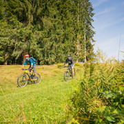
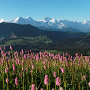
This spectacular tour sets off in Habkern with an ascent to Waldeggallmi. Although technically easy, the climb will still require an investment in sweat and effort. Once you have reached the top, the route leads steadily downhill, albeit constantly up and down all the way. The entire route runs in a westerly direction on mainly asphalted side roads above deep blue Lake Thun. Well-kept homes, snow-capped peaks and the lake below create a classic picture-postcard idyll. The views from Beatenberg of the iconic triple peaks of the Eiger, Mönch and Jungfrau are breathtaking. After you have passed through Beatenberg (Europe's longest village!), the route descends to Wiler and then by way of Schwanden and Teuffenthal via Steffisburg to Thun. Leave your everyday cares behind on this fantastic tour – with impressions that will linger long after you've reached your destination, the scenic town of Thun.
Good to know
Best to visit
Directions
Additional information
Information regarding duration, fitness requirements and technique depend on the chosen bike type (i.e. mountain bike, e-bike, touring bike, racing bike). These are approximate guidelines.
Interlaken Tourismus
Marktgasse 1
CH-3800 Interlaken
+41 (0)33 826 53 00
mail@interlakentourism.ch
www.interlaken.ch
Safety guidelines
Nearby


